Proposed
concept plan

Land Use Redesignation and Subdivision application

Trusted handyman services

B&A Planning Group, on behalf of Hans van den Bosch, is pursuing a Concept Plan, Land Use Redesignation and Subdivision application for a site in Mountain View County. The development will be a commercial/industrial business park located near the Town of Olds, directly west of Netook Crossing Business Park.

About the Project

  • Located at NW 35-32-1-5 in Mountain View County

  • Total site area 62.26 ha (153.83 acres)

  • The proposed plan is for an industrial/commercial business park

  • Concept Plan is required for entire quarter section

  • Phase 1 is 20.32 ha (50.20 ac), will require a Land Use Redesignation & Subdivision Application

  • Phase 1 requires rezoning from agricultural district to business park district and subdivision application for the creation of eight (8) new parcels

Proposed Development Concept

The site is in an area identified by the County’s Municipal Development Plan as appropriate for an industrial/commercial business park. A Concept Plan will be developed for the entire quarter section. The first phase of the project requires a rezoning from agricultural district to business park and subdivision application for the creation of eight (8) new parcels identified in the figure below.
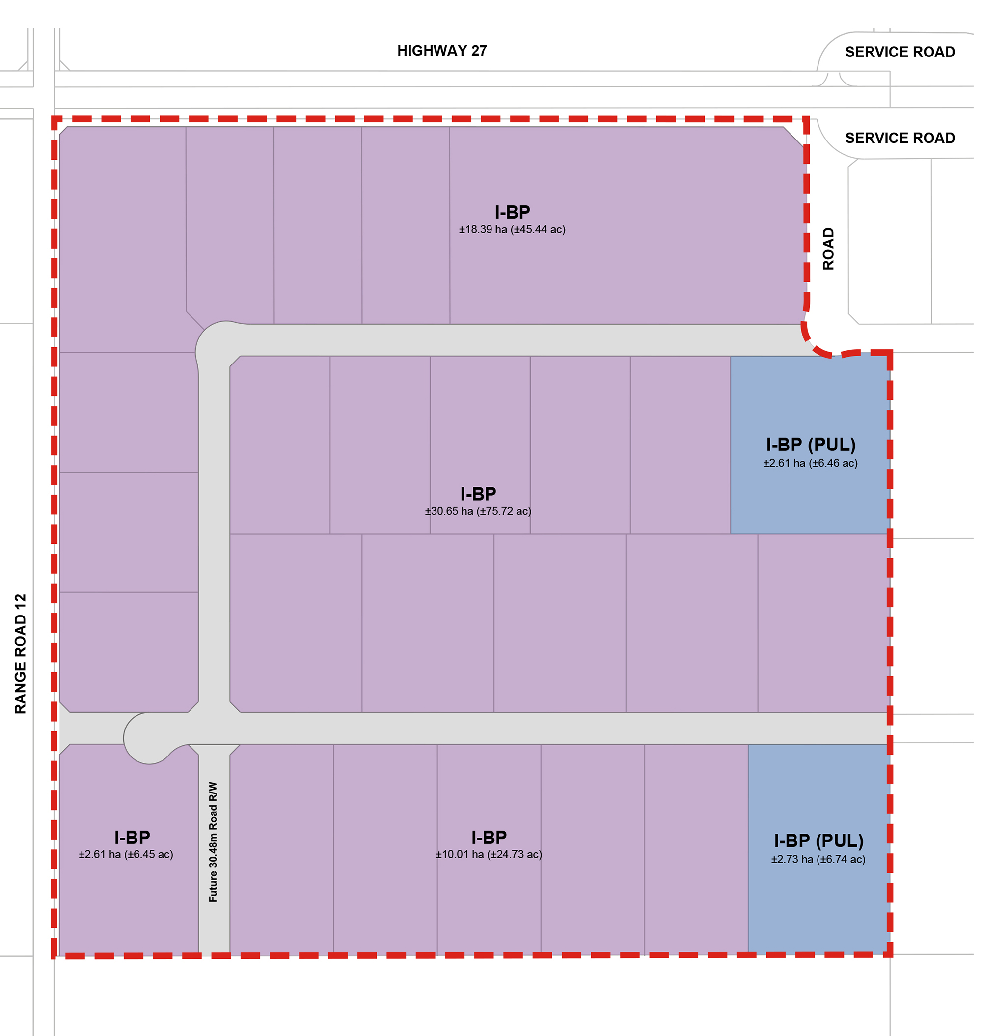
Proposed Site Plan

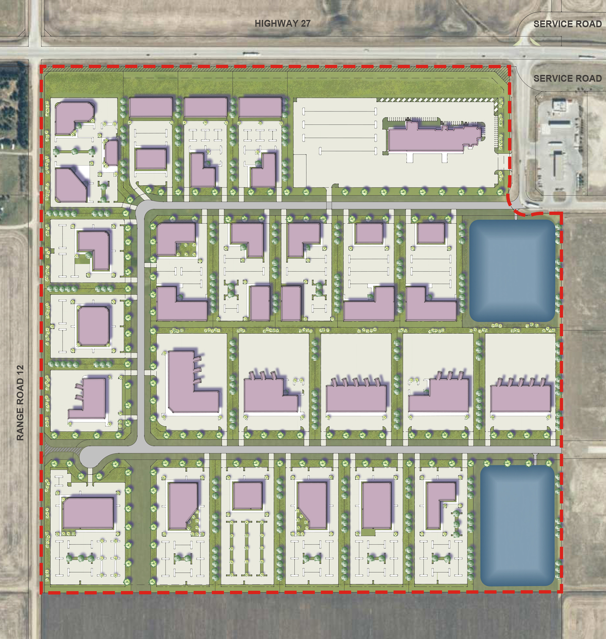
Conceptual Site Design

Frequently Asked Questions

B&A Planning Group is committed to providing the community with clear project information and responses to all stakeholder questions. The FAQ section includes information on key project components and will be updated to reflect questions we receive throughout engagement:

The site is located on private land east of Olds, Alberta, and less than 1 kilometre (km) west of Highway 2. The site is 62.26 hectares and consist primarily of agricultural land, with a treed windrow surrounding a former farmyard. The site is currently being used for agricultural purposes. The site is currently zoned by Mountain View County as an Agricultural District (A). 

The area has been identified by the Municipal Development Plan as an economic node area appropriate for industrial and commercial business parks. The first phase of development will be rezoned from Agriculture (A) district to Business Park district (I-BP).

There is a wide range of allowable and discretionary uses under the Business Park district. They include commercial, retail, restaurants, schools, offices, hotels, parks, health care, utilities, automotive and farm equipment dealerships, industrial manufacturing, gas stations and more.

A Phase II environmental site assessment (ESA) was conducted to evaluate potential areas of environmental concern identified during a Phase I ESA; specifically, an on-site feedlot and off-site adjacent properties to the east (cardlock, oilfield services). The work entailed both soil and groundwater sampling for potential contaminants of concern. Based on the findings of the Phase II ESA (i.e. soil and groundwater chemistry results), no further environmental investigation is warranted prior to proceeding with development. 

A desktop Biophysical Assessment was conducted for the development lands. This assessment identified two non-permanent waterbodies and two non-permanent drainages, which are permitted to be removed through an application to Alberta Environment and Parks under the Water Act. The Water Act applies to wetlands, waterbodies, and watercourses and approval is required to impact any of these features. The proposed development lands also contain mature trees suitable for some nesting raptor species, including the species of conservation concern, prairie falcon, which is known to occur in this area; as such, these existing mature trees may be integrated into the development where practical. 

A groundwater supply evaluation is being conducted by a qualified hydrogeologist on the proposed development. Water is proposed to be supplied to a commercial development via water wells installed at each commercial lot. The objective of the evaluation is to ascertain whether County-stipulated groundwater resources may be available to service the development without adversely impacting quality and quantity of groundwater within the development and existing users in the surrounding area. This assessment is an initial step in determining aquifer yield at water wells installed at each lot at the development. Currently a cumulative effects assessment is underway to assess potential maximum pumping rates attainable if multiple wells were operating simultaneously, such that adverse impacts to proposed and existing users does not occur. Ultimately, each well will need to be assessed by installing, testing, and reporting in support of a licence application to Alberta Environment and Parks (AEP) by each lot owner. This work is required to provide proposed and existing users assurances that adverse impacts will not occur.  

The business park will be serviced with natural gas, power and telecommunications. Water will be provided through individual water wells to each property as well as on-site septic storage. Both storm ponds provided within the site will have fire tanker truck access to support fire suppression needs. 

The road network will include one primary access point into the proposed development via Highway 27 and Range Road 11. This access will be shared with the existing Netook Crossing development. An emergency access will also be provided at Range Road 12. 

Traffic in the area is expected to change with the full build out of the first phase. An overall increase is expected to be 53% over curent levels by 2032. With this increase, the intersection of Highway 27 is proposed to be upgraded to a single-lane roundabout.  

Full build-out of the entire business park (including the balance of the Netook Crossing development area) is not expected until at least 2042. The entire build-out is expected to increase overall traffic at Highway 27 by approximately 287% over current levels. A multi-lane roundabout would be constructed to accommodate the traffic from the fully built-out area. 

The timing for intersection improvements at the intersection of HWY 27 and Range Road 11 is dependent on the speed at which development occurs, including further development within the Netook Crossing development area. The timing of improvements also depends on further input from Alberta Transportation and Mountain View County. 

For questions and comments, please contact our engagement representative Martha McClary at mmcclary@bapg.ca or 403.692.5230 

Project Timeline & Process

Get involved

Thank you for attending the online Public Information Session on February 2, 2022. A recording of the session along, the presentation content and the public engagement What We Heard Report can be found below.

For questions and comments, please contact our Engagement Specialist Martha McClary: